| PROJECT BACKGROUND
Although the project, due to its nature, may be linked to numerous previous or on going research directions, it has been independently developed, and has its specific and original objectives. The Vrancea seismogenic zone is one of the most active seismic areas in Europe, and in recent years, national and international research and working groups started to focus their research efforts on understanding the dynamics and behavior of this unique region. A series of contrasting alternative scenarios for geodynamic setting of the Vrancea zone have been proposed: oceanic slab subduction followed by slab break-off, oceanic slab subduction and lateral tearing, continental lithospheric delamination and unstable triple junction. However, consensus on which model represents the origin and dynamic behavior of the Vrancea seismogenic zone has not been forthcoming.
There are several principal directions that motivate this effort.
a) The origin of the seismogenic zone in Vrancea is still an ongoing debate. Recent tomography studies (Martin et al., 2006) revealed a high velocity body beneath Vrancea area, extending down to ~400 km depth (Fig.1).
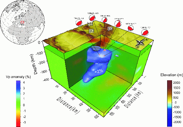
Figure 1. 3D seismic tomographic image (Martin et al., 2006) and hypocenters of the earthquakes (white dots represent the intermediate-depth seismicity from Oncescu et al. (1999) and red circles are the largest events). The blue isosurface is the 2% positive P-wave anomaly. The top surface represents the topography. Beachballs of the focal mechanism solutions are in map view.
Also, recent results of a temperature inversion of the P-wave velocity model by Ismail-Zadeh et al. (2008), show a low temperature anomaly (~-300°C) beneath Vrancea (Fig. 2).
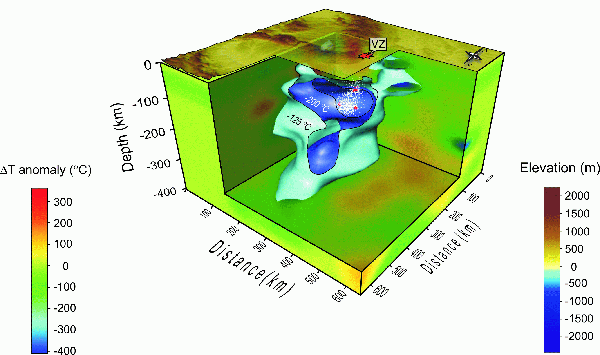
Figure 2. 3D view of the present day temperature model (Ismail-Zadeh et al., 2008) obtained from the inversion of P-wave velocity model (Martin et al., 2006). The two isosurfaces (light and dark blue) represent the -125°C and -200°C temperature anomalies beneath Vrancea Zone (VZ). The white dotes mark the intermediate-depth seismicity and the red dots are the largest events.
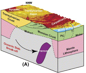
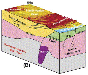
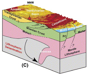
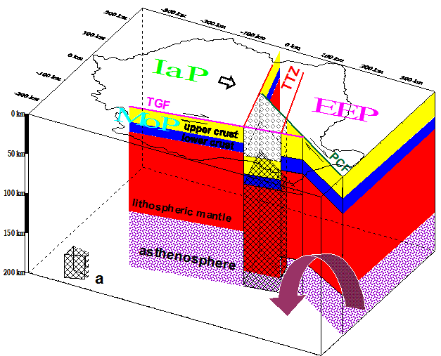
Several geodynamic models have been proposed and some of them were also studied by numerical means (Ismail-Zadeh et al., 1996; Cloetingh et al., 2004; Ismail-Zadeh et al., 2008; Lorinczi and Houseman, 2008). Slab detachment (Girbacea and Frish, 1988; Wortel and Spakman, 2000), delamination (Enescu, 1993; Gwisman, 2002; Knapp et al., 2005) and more recently an unstable triple junction (Besutiu, 2003) are example of the models proposed (Fig. 3).Several geodynamic models have been proposed and some of them were also studied by numerical means (Ismail-Zadeh et al., 1996; Cloetingh et al., 2004; Ismail-Zadeh et al., 2008; Lorinczi and Houseman, 2008). Slab detachment (Girbacea and Frish, 1988; Wortel and Spakman, 2000), delamination (Enescu, 1993; Gwisman, 2002; Knapp et al., 2005) and more recently an unstable triple junction (Besutiu, 2003) are example of the models proposed (Fig. 3).
Figure 3. Geodynamics scenarios proposed by Knapp et al. (2005) and Besutiu (2003). (A) Oceanic slab subduction and break-off. (B) Oceanic slab subduction and progressive lateral tear within the Carpathian foreland. (C) Continental lithospheric delamination. (D) Unstable triple-junction.
Subduction and lateral tearing of an oceanic slab beneath the Eastern Carpathians is considered the most popular model. However, recent studies (Knapp et al., 2005) argue that this interpretation is not entirely consistent with geologic constraints (i.e. Vrancea zone is located in an area overlain by continental crust rather than oceanic crust). However, 3D modelling coupled with tectonic evolution of the SE-Carpathians will shed light on the validity of this model.
The delamination model proposed by Knapp et al. (2005) is an alternative model based on the Miocene closure of an intra-continental basin and it needs to be validated by 3D numeric modelling.
The most recent model is associated with an unstable triple junction and related with the opening of the Black Sea basin and the large differences in thicknesses among the three lithospheric compartments that join beneath Vrancea. Such a complex tectonic scenario requires a sophisticated 3D modelling approach and can be achieved only using a computing cluster.
A cyberinfrastructure is essential to the success of research in the field of computational geodynamics. Support of such state-of-the-art research is expected to contribute to many of the scientific achievements related with the Vrancea seismogenic area.
Because of important advances in computing and related information technology and the availability of highly specialized parallel codes for complex 3D geodynamic models, it is timely to undertake a systematic study on the origin and dynamic behaviour of the Vrancea seismogenic zone.
Question like: What is the main origin of intermediate depth seismicity? Which is the mechanism that gave birth of this intensely seismic area (slab detachment, delamination or an unstable triple junction)? Why the epicentral area that currently subsiding is spatially very confined? Do the main fault zones that bound the epicentral area play a significant role on the general dynamic behaviour of this area? Which geodynamic model satisfies most observations or constraints?
These questions - and others - have been a matter of debate for a long time, but only now they are coming within our ability to answer because of advances in computing and related information technology. In this proposal, we seek support for building for the first time in Romania a state-of-the-art cyberinfrastructure in order to perform 3D geodynamic modelling and visualization associated with the Vrancea seismic zone.
Our strategy is to perform deformation models with realistic rheologies and the integration of the modelling results with field observations. We propose to perform a series of models with different input scenarios (plate reconstructions) and configuration (fault distribution) and identifying those parameters that exert first-order control on the dynamic behaviour of Vrancea zone. Our approach combines the capability of a High Performance/Visualization Computing Cluster (HPCC/HPVC), 3D geodynamical modelling techniques with input from field observations, creating a state-of-the-art cyberinfrastructure for geodynamic studies. Such approach gives us the ability and the opportunity to answer key questions related with this unique and particular seismic area. Several recent studies (Knapp et al., 2005; Besutiu, 2003) have proposed several plausible geodynamics scenarios for the Vrancea zone. We seek to advance these working hypotheses with the help of numerical modelling. The goals of the proposed research are to evaluate the strengths and weaknesses of these scenarios by creating a cyberinfrastructure at the Institute of Geodynamics of the Romanian Academy of Sciences. Using efficiently such infrastructure we believe we are in an excellent position to make significant progress on understanding the complex dynamics of the Vrancea seismogenic zone.
In order for the cyberinfrastructure development to succeed in creating useful, long-lasting, and successful scientific results, several things are essential:
-We need to build a scalable/upgradeable HPCC/HPVC system;
-We need to train scientists how to run/compile/debug parallel codes and visualize large data sets with the HPCC/HPVC;
-We need to perform a systematic approach of modelling different geodynamics scenarios related with the Vrancea seismogenic zone;
-Successful cyberinfrastructure development is not a solitary activity; it rather depends on constant communication and interaction between all scientists and students involved in this project.
REFERENCES
♦ Besutiu, L., 2003. Plate tectonics on the Romanian territory. Dynamics and some seismotectonic consequences: in Hain, V.E., Gherasimov , M.E. (Eds), Problemî geodinamiki i neftegazonosti Tchernomorskovo-Kaspiiskovo regiona, p.19-23, Simferopol
♦ Cleotingh, S.A.P.L., Burov, E., Matenco, L., Toussaint, G., Bertotti, G., Andriessen, P.A.M., Wortel, M.J.R., Spakman, W., 2004. Thermo-mechanica lcontrols on the mode of continental collision in the SE Carpathians (Romania). Earth and Planetary Science Letters, 218, 57-76.
♦ Enescu, D., 1992. Lithosphere structure in Romania. I. Lithosphere thickness and average velocitie of seimic waves P and S. Comparison with other geophysical data. Revue Roumain du Physique., 37, 623-639.
♦ Girbacea, R., Frisch, W., 1988. Slab in the Wrong place; Lower lithospheric mantle delamination in the last stage of the Eastern Carpathian subduction retreat. Geology, 26, 611-614.
♦ Gwirtzman, Z., 2002. Partial detachment of a lithospheric root under the southest Carpathians: toward a better definition of the detachment concept. Geology, 30, 51-54.
♦ Ismail-Zadeh, A.T., Keilis-Borok, V.I., and Soloviev, A.A., 1999. Numerical modeling of earthquakes flows in the southestern Carpathians (Vrancea): Effect of a sinking slab. Physics of the Earth and Planetary Interiors, 111, 267-274.
♦ Ismail-Zadeh, A.T., Schubert, G., Tsepelev, I., and Korotkii, A., 2008. Thermal evolution and geometry of the descending lithosphere beneath the SE-Carpathians: an insight from the past. Earth and Planetary Science Letters, 273, 68-79.
♦ Knapp, J.H., Knapp, C.C., Raileanu, V., Matenco, L., Mocanu, V., Dinu, C., 2005. Crustal constraints on the origin of mantle sesimicity in the Vrancea Zone, Romania: the case for active continental lithospheric delamination. Tectonophysic 410, 311-323.
♦ Lorinczi, P., Houseman, G.A., 2008. Lithospheric gravitational instability beneath Southeast Carpathians. Tectonophysics, doi: 10.1016/j.tecto.2008.05.024
♦ Martin, M., Wenzel, F., and the CALIXTO working group, 2006. High-resolution teleseismic body wave tomography beneath SE-Romania-II. Imaging of a slab detachment scenario. Geophysical Journal International, 164, 579-595.
♦ Oncescu, M.C., Marza, V.I., Rizescu, M., si Popa, M., 1999. The Romanian esrthquake catalogue between 1984-1996. In: Vrancea Earthquakes: tectonics, Hazard, and Risk Mitigation, Wenzel, F., Lungu, D., and Novak, O. (eds.), Kluwer Academic Publishers, Dordrecht, Netherlands, 43-47.
♦ Wortel, M.J.R., Spakman, W., 2000. Subduction and slab detachment in the Mediterranean-Carpathian region. Science, 290, 1910-1917.
|