|
76NEWS on 2014-02-25 04:23:29Project Endedby marina |
|
|
|
|
|
Welcome !
|
  
|
Warning: mysql_result() expects parameter 1 to be resource, boolean given in /var/www/cyberdyn/html/stats/stats.php on line 2
You are visitor no. since 10/14/2010 Visitors Online: Members Online: 0
Page updated:
|
@NLINE APPLICATIONS.::.GEOMODELS.::.ContinentCOLLISION
Cyberinfrastructure for Geodynamic Studies Related to the Vrancea Seismogenic Zone
ContinentCOLLISION - Crustal deformation associated to continental collision
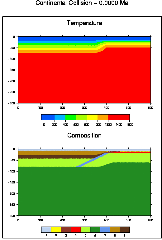
Continental collision is another geodynamic scenario addressed by numerical modelling and performed with the HPCC CyberDyn. This numeric setup follows Gerya (2010) as model uses an internal evolving erosion/sedimentation surface (Gerya and Yuen, 2003) that separates the top boundary of the lithosphere from the overlaying sticky water/air layer with vertically stratified density (either 'air', 1 kg/m3, for y < ywater or 'water', 1000 kg/m3, for y>ywater, where ywater is the water level adopted in the model). The model setup incorporates an oceanic lithosphere initially present between the two continental plates, allowing a more natural beginning and more faithfully captures the initial stages of the collision process. During these stages, the model behavior changes rapidly due to the arrival of the positively buoyant continental crust in the subduction zone. The model domain is 1000x300 km and uses a non-uniform 201x61 rectangular grid with a constant high resolution of 2 x2 km in the 300x60 km area of the subduction/collision zone. Coarser resolution around this zone changes at every time step in response to the model shortening (leftward) and thickening (downward), which accommodate the convergence whose velocity is prescribed at the right model boundary. Boundary conditions are as following: the model is shortening and the left boundary does not change position with time. In order to compensate for the thickening of the sticky air/water layer on the top of the model, the water level changes at every time step. The continental crust is 35 km thick, with the upper and lower crustal layers of equal thickness. The nucleated subduction zone at the left ocean/continent boundary is prescribed as a 4 - 15 km wide weak zone cutting across the entire mantle lithosphere and reaching a depth of 90 km. The weak zone is prescribed as a wet brittle/plastic fault within mantle rocks, characterised by wet olivine rheological parameters and a low plastic strength of 1 MPa (i.e. assuming a high pore fluid pressure and sin(φ)=0). During subduction, the pre-defined weak zone is spontaneously replaced by weak subducted crustal rocks, thereby preserving the decoupling along the interface.
Gerya, T. V. and Yuen, D. A. (2003) Rayleigh - Taylor instabilities from hydration and
melting propel cold plumes at subduction zones. Earth and Planetary Science
Letters, 212, 47 - 62.
Gerya, T.V. (2010) Introduction to Numerical Geodynamic Modeling,Cambridge University Press.
|
| INITIAL SETUP
|
|
|
|
|
|
|
|